")
")


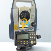
Leica Geosystems TS06-1 | 1″ Precision Total Station & Carrying Case
Leica Geosystems TS06-1 Product Information
The Leica FlexLine TS06-1 is a manual total station that works well for situations that need mid to high accuracy. It makes complicated field activities easier by combining Swiss accuracy with an easy-to-use UI. The “TS06-1” stands for its 1-arc-second angular accuracy, which makes it the most accurate model in the TS06 line.

This package comes with the Carrying Custodia (Rugged Transport Case) and is marked “Test Power No Calibrate.” This usually means that the unit has been powered on and tested for basic performance, but it may need a new professional calibration certificate before being used in high-stakes situations. It can take measurements very quickly on both prisms and surfaces without reflectors thanks to its PinPoint EDM technology.
| Feature | Specification |
| Angular Accuracy | 1″ (0.3 mgon) |
| Distance Range (Prism) | Up to 3,500 m (Single GPR1 Prism) |
| Reflectorless Range | PinPoint R500 (>500 m) or R1000 (>1,000 m) |
| Distance Accuracy (Prism) | 1.5 mm + 2.0 ppm |
| Distance Accuracy (Reflectorless) | 2 mm + 2 ppm |
| Display | High-resolution black and white graphics (160 x 280 pixels) |
| Keyboard | Full alphanumeric with five levels of brightness |
| Internal Memory | Max 100,000 fixpoints / 60,000 measurements |
| Battery Life | About 30 hours (Li-Ion) |
| Weight | 5.1 kg (with the battery and tribrach) |
| Environmental Protection | IP55 (Dust and water resistant) |
| Operating Temperature | -20°C to +50°C |
Applications:
Land surveying includes boundary surveys, topographic mapping, and cadastral work.
Construction: Setting up the building, making sure the base is level, and making very precise stakeouts.
Civil Engineering: Designing and keeping an eye on roads, bridges, and tunnels.
Mining: figuring out how much space the mine takes up and keeping an eye on how the structure changes shape.
Utilities mapping and big-picture city planning are part of infrastructure.
Related products